Caribbean Islands bioregion
The bioregion’s land area is provided in units of 1,000 hectares. The conservation target is the combined Global Safety Net (GSN1) areas for the component ecoregions. The protection level indicates the percentage of the GSN goal that is currently protected on a scale of 0-10. N/A means data is not available at this time.
The Caribbean Islands bioregion, located in the Caribbean subrealm in the Central America realm, incorporates all 700 of the islands and islets of the Caribbean Sea, with the exception of Aruba, Curaçao, and other small islands just off the coast of Venezuela. It also includes the Everglades in the southern tip of Florida, which demarcates the transition between the Nearctic and Neotropical realms. The islands contain a mixture of dry and moist forests, both broadleaf and conifer, surrounded by mangroves. The largest island, Cuba, is mostly dry broadleaf forest with extensive flooded grasslands and some cactus scrub. The bioregion contains 19 terrestrial ecoregions altogether—Cuban Moist Forests (459), Hispaniolan Moist Forests (468), Jamaican Moist Forests (472), Leeward Islands Moist Forests (475), Puerto Rican Moist Forests (495), Windward Islands Moist Forests (517), Cuban Dry Forests (530), Hispaniolan Dry Forests (532), Jamaican Dry Forests (535), Lesser Antillean Dry Forests (537), Puerto Rican Dry Forests (543), Bahamian Pineyards (552), Cuban Pine Forests (554), Hispaniolan Pine Forests (555), Cuban Wetlands (579), Enriquillo Wetlands (580), Everglades Flooded Grasslands (581), Caribbean Shrublands (599), Cuban Cactus Scrub (600)—with extensive mangroves, including the Bahamian-Antillean Mangroves (612), across all the islands. The total area of this bioregion is over 24 million hectares, not including adjacent marine areas.
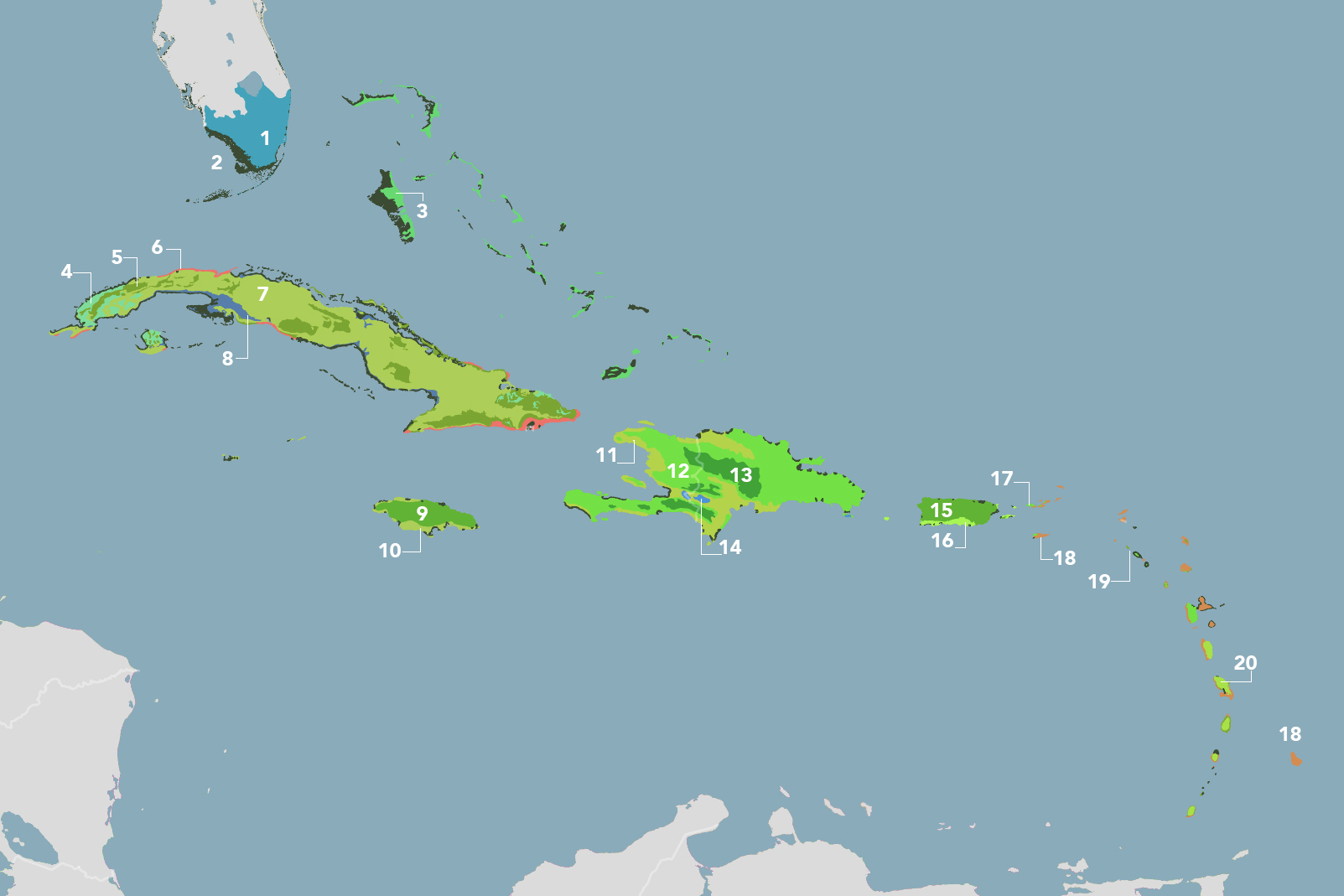
The Caribbean Islands bioregion is part of the Caribbean subrealm and is made up of 20 ecoregions: (1) Everglades Flooded Grasslands (2) Bahamian-Antillean Mangroves (3) Bahamian Pineyards (4) Cuban Pine Forests (5) Cuban Moist Forests (6) Cuban Cactus Scrub (7) Cuban Dry Forests (8) Cuban Wetlands (9) Jamaican Moist Forests (10) Jamaican Dry Forests (11) Hispaniolan Dry Forests (12) Hispaniolan Moist Forests (13) Hispaniolan Pine Forests (14) Enriquillo Wetlands (15) Puerto Rican Moist Forests (16) Puerto Rican Dry Forests (17) Leeward Islands Moist Forests (18) Caribbean Shrublands (19) Lesser Antillean Dry Forests (20) Windward Islands Moist Forests.
Learn more about each of the Caribbean Islands ecoregions below.
Explore the Bioregions
Want to learn more about the fascinating species, diverse ecosystems, and natural wonders of the Earth? Click the button below to launch One Earth's interactive navigator and discover your Bioregion!
LAUNCH NAVIGATOR