Cross-Niger Transition Forests
The ecoregion’s land area is provided in units of 1,000 hectares. The conservation target is the Global Safety Net (GSN1) area for the given ecoregion. The protection level indicates the percentage of the GSN goal that is currently protected on a scale of 0-10. N/A means data is not available at this time.
Bioregion: Gulf of Guinea Coastal Forests & Mangroves (AT17)
Realm: Afrotropics
Ecoregion Size (1000 ha):
2,077
Ecoregion ID:
6
Conservation Target:
3%
Protection Level:
10
States: Nigeria
The Cross-Niger Transition Forests are found nestled between the biogeographic barriers of the Cross River and the formidable Niger River. These remnant forests harbour species which are transitional between the Upper Guinean and Lower Guinean forest blocks of the Guineo-Congolian regional center of endemism. Despite being in close proximity to these highly biodiverse regions, the Cross-Niger forests contain extremely low rates of endemism for a tropical forest.
This ecoregion is found in southern Nigeria and most of its relief is low and undulating with few notable topographic features. Bedrock dating to the Upper Cretaceous underlies the northern part of the ecoregion, while to the south the deposits are from the Tertiary. Other than the Niger and Cross Rivers, only two other large rivers, the Imo and the Kwa Ibo, drain this ecoregion.

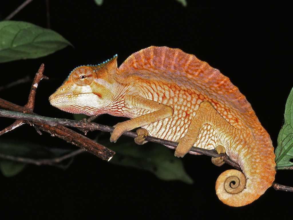
The flagship species of the Cross-Niger Transition Forests ecoregion is the crested chameleon. Image credit: Courtesy of Bernard Dupont, Flickr
Three vegetation zones cross the ecoregion south to north, reflecting decreasing rainfall further inland. The rainforest zone in the south has 2,000–2,500 mm of annual rainfall, commonly dominated by members of the Leguminosae and the Meliaceae families, such as Brachystegia spp., Cylicodiscus gabunensis, and Gossweilerodendron balsamiferum.
The mixed deciduous forest zone further north is drier with 1,500-2,000 mm rainfall per annum and the parkland zone which is even further north is drier still. They were probably once dominated by members of the Sterculiaceae, Moraceae, and Ulmaceae families, including Cola spp., Mansonia altissima, Antiaris africana, Ficus spp., Celtis spp., and Holoptelea grandis.
Today, cultivation and fire have destroyed much of the rainforest and other natural habitats. Regular burning favors grasses and fire-hardy, gnarled trees, replacing the vegetation with grass species such as Andropogon gayanus and A. schirensis and trees such as Annona senegalensis. Agriculture also removes natural tree cover.
There are two near-endemic species, the Sclater’s guenon and the crested chameleon, whose distribution ranges are mainly restricted in this ecoregion. The Anambra waxbill is another near-endemic bird typical of the Cross-Niger region. Compared with adjacent ecoregions, strict endemism is relatively very low in the Cross-Niger Transition Forests: there are no endemic amphibians and strict plant endemics are few in number.
Additionally, few plant species of restricted distribution seem to be found here. The Niger River remains a significant barrier to animal species from the west. On the other hand, the Cross River, which forms this ecoregion’s eastern boundary, is much smaller a river and therefore less of a barrier. The absence in this ecoregion of a number of species found in the neighboring Cross-Sanaga-Bioko Coastal Forest ecoregion may, therefore, be more an artifact of the high level of deforestation in this ecoregion than a genuine biogeographical feature.
Archeological evidence indicates that high human population densities are not a recent phenomenon; in the 19th century AD the levels of human activity were already considerable. Population densities are between 100 and 500 people per km2. Conversion to agriculture, small-scale logging, and hunting of the native fauna for bushmeat is long-standing and little habitat and few animals survive, to the extent that bats and frogs, animals that are generally avoided in Africa have become part of the local diet. The few remaining species of mammals that thrive in farmland, such as the greater cane-rat, are sold for high prices.
%20Jadek555.jpeg)
Greater cane rat (Thryonomys swinderianus). Image credit: Jadek555, Creative Commons
Anthropogenic fires have also altered and destroyed native vegetation. The high level of deforestation is the most likely reason for the absence of large mammals and reports from the 1940s indicate that large animals were already extremely scarce. During colonial times so little forest remained in this area that logging companies did not take much of an interest and forestry departments did little to establish forest reserves.
More recently, forest reserves have been established: Anambra (194 km2), Mamu River (70 km2), Osomari (115 km2), Akpaka (194 km2), and Stubbs Creek (210 km2). Most of these reserves have been converted in to plantations of exotic tree species. Stubbs Creek Forest Reserve contains one of the few remaining larger blocks of natural forest. The other intact forest patches are mainly in traditionally protected sacred groves, although these traditions are starting to lapse. This protection extends to populations of Sclater’s guenon associated with these groves.
The priority conservation actions for the next decade will be to: 1) Empower local communities for sustainable use of natural resources and improve livelihoods; 2) reforest and improve the management of the current forest reserves; and 3) retain and improve management of existing protected areas.
Citations
1. Critical Ecosystem Partnership Fund. 2015. Ecosystem Profile: Guinean Forests of West Africa Biodiversity Hotspot.
2. Nigerian Conservation Foundation. 2018. Biodiversity Action Plan – Edo. [Online]. [Accessed 9 January 2018]. Available from: http://www.ncfnigeria.org/projects/biodiversity-action-plan-edo
3. White, F. 1983. The vegetation of Africa, a descriptive memoir to accompany the UNESCO/AETFAT/UNSO. United Nations Educational, Scientific and Cultural Organisation. Paris: France.


