What is a bioregion?
There is a lot of excitement about bioregions these days, but there is also some confusion about what that term means, along with related terms like “bioregional” or “bioregionalism.”
The simplest definition of a bioregion is any geographical area defined not by political boundaries but by ecological systems. The major dictionaries offer similar definitions of the word “bioregion”:
- Merriam-Webster: “a region whose limits are naturally defined by topographic and biological features (such as mountain ranges and ecosystems)”
- Dictionary.com: “An area constituting a natural ecological community with characteristic flora, fauna, and environmental conditions and bounded by natural rather than artificial borders”
- Cambridge: “A region that has a particular type of natural environment and natural features. It is sometimes defined as smaller than an ecozone but larger than an ecoregion”
- Collins: “a natural ecological community in which the biodiversity and ecosystem are distinct”
- Oxford Reference: “a territory defined by ecological systems (such as drainage basins or ecosystems), rather than by political or administrative units... an area of relatively homogeneous ecological characteristics”
All of these definitions are correct, but they only scratch the surface when it comes to defining the concept of a bioregion, which is built upon decades of scientific literature and is constantly evolving and becoming more and more sophisticated over time.
At One Earth, we worked in consultation with numerous scientific experts over a span of five years to develop a new complete set of discrete bioregion polygons, spanning the entire globe across land and sea. This framework builds upon numerous scientific frameworks, in particular, the Ecoregions 2017* data set, and is explained in detail on our Bioregions 2023 overview page.
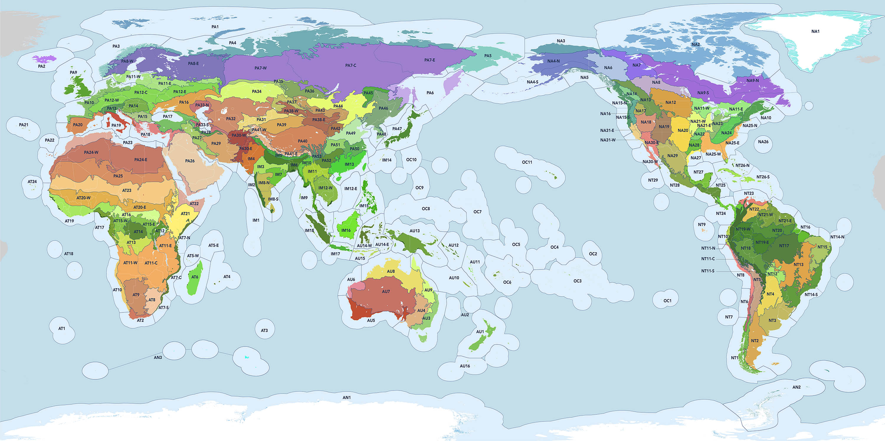
Bioregions 2023: a new map of the Earth created by intersecting biomes with large-scale topographic features and ecoregional groupings to delineate 185 discrete bioregions. Download Map (6 MB). Credit: Karl Burkart, One Earth
The purpose of the One Earth bioregion map is to offer a way for anyone anywhere to find their bioregion in our 3D Navigator, and learn about the array of plants and animals that define each component ecoregion contained within. We have over 1000 pages of content and photography submitted from around the world to document the bioregions, along with a dashboard for each, showing the extent to which they are protected or conserved.
All that being said, this is just one approach to defining a bioregion. The Earth is a complex system of systems, and that means any ecological system could be used to define or delineate a bioregion – from watersheds and species distribution to climate zones and geological structure. And the presence of humans on the land can play a role too, shaping the understanding of how a bioregion was defined in the past and how it might be in the future (we’ll get to that later in the section on Bioregionalism).
22 ways to define a bioregion
There is a long and storied history of the word “bioregion,” tracing back to the first documented use of the term in a 1971 scientific paper on, of all things, the biogeography of blue crabs in Louisiana. Fifty years on, there are now more than 65,000 academic papers using the term, and it is growing every year — 4,400 articles were added just last year!
-1600x1200%20(1)-3200x2400%20(1).jpg)
Blue crab (Callinectes sapidus). Image credit: Phils 1st Pix via Flickr, CC BY-NC-SA 2.0
If you’re a serious geek, I go into detail on the history of the use of “bioregion” and related terms in my Medium post A brief history of bioregions and bioregionalism in scholarly literature. It really is a fascinating history involving two very different groups of people thinking about bioregions in very different ways – one centered on the science of biological diversity and the other centered on human experience.
On the science side, an important paper in 2015 by Daril Vilhena and Alexandre Antonelli — “A network approach for identifying and delimiting biogeographical regions” -- summarizes the state of play after four decades of work developing bioregional frameworks:
Here's a mostly complete list of biotic (biological) approaches to defining bioregions within the context of scientific literature [3]:
- realm: the broadest biogeographic division of Earth's land surface, based on distributional patterns of terrestrial organisms (i.e. continent-scale)
- province: specific geographic areas on land and sea delineated by common landforms and ecological conditions (sub-continent scale)
- biome: a typology for large-scale areas characterized by vegetation, soil, climate, and wildlife (e.g. forests, grasslands, deserts)
- ecozone: a division of the Earth’s land surface distinguished by the evolutionary histories and distribution patterns of its life forms (spanning biomes)
- ecosystem: a specific community of interacting organisms and the interactions of biotic and abiotic components in a given area
- ecoregion: areas which harbor ecosystems that are generally similar in character as defined by prevalent flora and fauna
- zoogeographic region: areas with relatively uniform climatic conditions defining distinct animal populations
- phytogeographic region: areas with relatively uniform climatic conditions defining distinct plant populations
- chorotype: the delineation of groups of species that have coincident ranges (there are two differing uses of the term in biogeography)
- areas of endemism (AoE): a single defined geographic location that is the only place where a particular species (or several species) can be found (e.g. islands)
- concrete biota: all the flora and fauna species encountered in all habitats within an area surrounding a particular locality
- nuclear area/phytocorion: the specific area from which the genetic lineage of a particular plant or animal species originated
- chronofauna: a geographically restricted natural assemblage of interacting animal populations maintained over a geologically significant period of time
- horofauna: an assemblage of the animal groups that coexist and diversify in a given area over a prolonged time, representing a lasting biogeographic unit
- cenocron: a given area in which an animal or plant group or community has entered, wherever its origin, within a defined period of geological time
- generalized track: a graph of geographic distribution that connects the different localities or distribution areas of a particular taxon or group of taxa
- biogeographical domain: a macroecological region – a continent or group of continents or major bioclimatic regions – used to study the dispersal of particular species
- species assemblage: a group of organisms belonging to a number of different species that co-occur regionally and interact through trophic and spatial relationships
- habitat/biotope: the natural environment or “home” in which an organism or population normally lives through a significant portion of its life cycle
And then there are abiotic (non-biological) frameworks to define bioregions as well:
- climatological: maps of land divided based on patterns of seasonal precipitation, humidity, and temperature (e.g. Köppen climate classification)
- topographical: maps of the forms and features of land surfaces creating natural boundaries across distance and elevation (e.g. mountains, ravines, basins, plateaus)
- hydrological: maps of drainage basins or ‘watersheds’ where all flowing surface water converges to a single point, such as a spring or lake, or flows into another body of water
All of these can be intersected in different ways to formulate bioregional configurations for various purposes. The Vilhena & Antonelli paper is particularly interesting in applying modern network theory to specifically map global amphibian populations, offering a new data-driven approach to identifying and delimiting the world’s biogeographical regions. A modeling software called Infomap Bioregions was subsequently released to create maps based on an array of species ranges -- supporting efforts to protect, conserve, and manage the natural world with specific threatened species in mind.
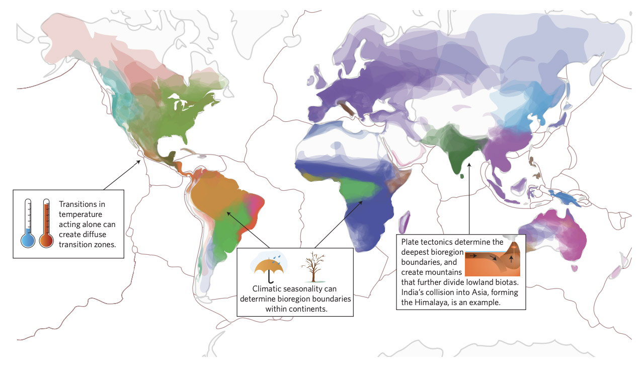
Ranges of amphibian species colored by biogeographical region showing the role of plate tectonics, climatic transitions, and mountain barriers in forming bioregions across the globe. Map by Daniel Eldler, DOI: 10:1038/s41559-017-0114 (2017)
While there are a variety of ways to define them, bioregions now have wide adoption not only by scientists but also by governments and NGOs. For example, the US Geological Survey (USGS) offers bioregion maps and resources for different regions (e.g. “Bioregions of the Pacific US), and some States, for example Florida and Kentucky, have created their own bioregion maps.
Several UN Food and Agriculture Organization (FAO) reports have referenced bioregions, and they’ve developed their own framework called Global Ecological Zones (GEZs). The International Union for Conservation of Nature (IUCN), which created one of the very first global-scale bioregional frameworks called “biotic provinces” in the early 1970s, now maintains the most widely used framework – the Global Ecosystem Typology (GET 2.0).
Bioregionalism: what about people?
There must have been something in the air in the mid-1970s. While the first scientific papers on bioregions were being written based on precisely measured biological phenomena, another group of individuals had a quite different conception of the word “bioregion” – focusing on the human, sociological, and cultural relationships between people and the ecosystems upon which they depend.
In his landmark essay “Bioregions: towards bioregional strategy for human cultures”, Allen Van Newkirk laid out the principles for what was to become known as “bioregionalism.” The ‘ism’ is important here. This is a social and philosophical movement. It’s not about the objective study of natural phenomenon, per se, but about the interactions between people and nature. Author Richard Evanoff credits Newkirk with bringing the word “bioregion” into the modern lexicon (though it was used earlier by practicing biologists). He also cites the work of Raymond Dasmann, Gary Snyder, and Peter Berg for creating this definition:
Bioregionalism as a concept seems to have started with a small group of thinkers and dreamers in San Francisco, and then it spread like wildfire. Two journals in particular – Planet Drum and The Trumpeter– were influential in disseminating the neo-tribalist ideas of Snyder and other visionaries. Thousands of articles were written on bioregions and bioregionalism, which covered a range of sociopolitical and cultural phenomena – concepts like deep ecology, ecofeminism, Indigenous lifeways, permaculture, land art, localism, and even sustainable development.
In the 1980s, a strong association between watersheds and bioregions was formed after early maps of the world’s global freshwater systems were published, documented in a seminal piece by J.J. Parsons entitled “On Bioregionalism and Watershed Consciousness.” Also, during this time, perhaps the most significant development was made -- the adoption of “bioculturalism” as a key part of bioregional thinking.
The term “biocultural” stemmed originally from the field of anthropology – studying the complex material and spiritual relationships between tribal communities and their environments. But it quickly became a key tenet of the bioregional school of thought. Here are some exemplary quotes describing this idea:
A bioregion.. is not just watersheds and biomes, but histories and cultures too. – The Alternative
Bioregionalism is a comprehensive way of defining and understanding the place where we live, with the aim to live in that place sustainably and respectfully. – Age of Awareness
The concept of a bioregion is an evolving and dynamic idea. The term bioregion attempts to define and determine the location of an individual in the biosphere, and to help each person develop a sense of place. – SCMBC
While bioregionalism acknowledges the science of biogeography, it is centered on the human experience. This is an important perspective, particularly as we seek to uphold and expand the rights of Indigenous peoples worldwide. We recognize that the traditional domains of Indigenous people are most certainly a type of bioregion. Just take a look at the amazing website Native-Land:
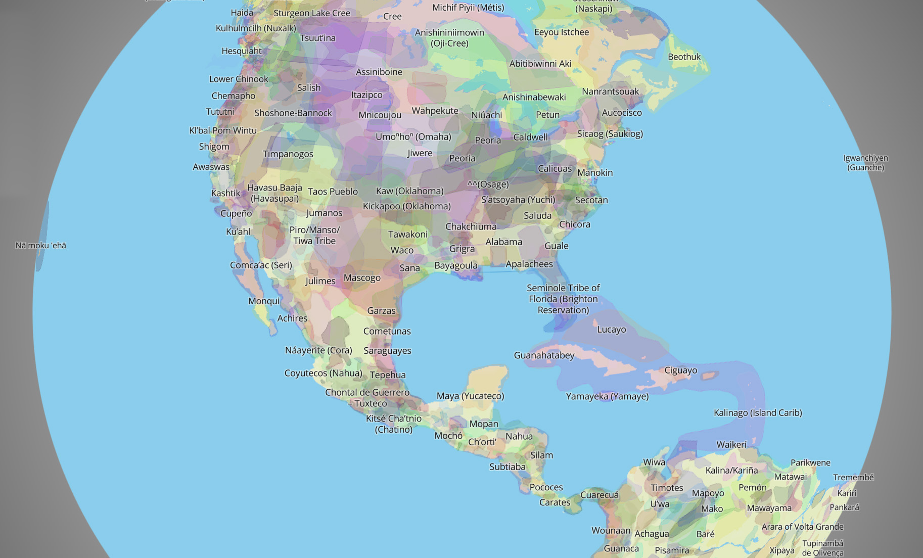
A map of historic and current tribal territories by Native Land Digital, 2024.
Thousands of overlapping polygons evolved over hundreds of years through the interactions between tribal nations and their ecosystems. If we are ever to hope to protect and conserve the natural world upon which we all depend, it will have to be in partnership with Indigenous peoples, who have deep biocultural ties to their lands and waters.
It was exciting to see this idea incorporated into the Fuzhou Declaration by the UN World Heritage Committee in 2021, which called for synergies between cultural and biodiversity-related conventions and reinforced international solidarity “…to preserve our shared cultural and natural heritage through fostering a new relationship of human beings with nature.”
These ideas were also woven into the new Kunming-Montreal Global Biodiversity Framework, adopted by nearly all the world’s governments in 2022, which, for the first time, explicitly recognizes Indigenous and traditional territories as a “third way” -- beyond formal Protected Areas (PAs) and other Conservation Measures (OECMs) -- to achieve the conservation goals of the UN agreement.
While the two major streams of work on bioregions – one biological and one sociological -- may have diverged over the past 50 years or so, they seem to be coming back together now as the conservation community embraces the role of biocultural traditions to help save species and restore critical ecosystems. Here’s one cool video we made on the topic:
* Note: The Ecoregions 2017 data set, developed with input from 50 regional and technical experts to define 844 terrestrial ecoregions data, provides a major update to the landmark paper “Terrestrial Ecoregions of the World: A New Map of Life on Earth” (Olson et al. 2001). Combined with the original paper, this Ecoregions framework is cited in nearly 11,000 academic studies, making it one of the most influential in the canon of ecological literature.
Explore One Earth's Bioregions